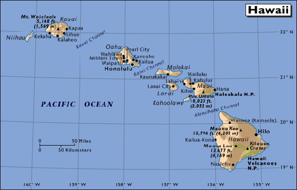
Hawaii is a group of more than 20 islands located on an archipelago in the central Pacific Ocean, southwest of the continental United States. The state was admitted to the Union on August 21, 1959, making it the 50th state. Its capital is Honolulu on the island of Oahu. The most recent census puts the state's population at 1,211,537.
The state encompasses nearly the entire volcanic Hawaiin Island chain, which is made up of hundreds of islands spread over 1,500 miles (2,400 km). At the southeastern end of the archipelago, the eight "main islands" are (from the northwest to southeast) Niihau, Kauai, Oahu, Molokai, Lanai, Kahoolawe, Maui, and Hawaii. The last is by far the largest, and is often called the "Big Island" or "Big Isle" to avoid confusion with the state as a whole. This archipelago is physiographically and ethnologically part of the Polynesian subregion of Oceania. Hawaii's tallest mountain, Mauna Kea stands at 13,796 feet and is taller than Mount Everest if followed to the base of the mountain — on the floor of the Pacific Ocean.
Popular outdoor activities include surfing, hiking, biking, hang-gliding, sailing, camping, snorkeling, scuba diving, windsurfing, parasailing, fishing, and even snow-skiing (on 13,000+ foot mountain peaks in winter).